01
Project Data Management
Create reusable project files, index active projects, and search by project number, name, client, location, or file.
GEOKAL is geotechnical engineering software for organizing investigation data, performing technical calculations, and producing consistent project deliverables.
GEOKAL brings common geotechnical workflows together so project information can move efficiently into calculations, logs, sections, summaries, and client-ready documents.
GEOKAL connects project organization, technical data, engineering calculations, and finished reporting in a single structured environment.
Create reusable project files, index active projects, and search by project number, name, client, location, or file.
Capture boring, lithology, groundwater, sampling, field-test, and laboratory data in one connected project record.
Compare laboratory results against field descriptions, update conflicting USCS information, and correct material descriptions to reduce repetitive manual editing.
Calculate SPT N-values, derive soil consistency or relative-density terminology from soil behavior and blow counts, and add or correct missing terminology. Missing USCS codes can be recovered from descriptions or laboratory results.
Choose preferred control types, build reusable popup choices, and create sample-interval presets that match an organization’s normal field and laboratory workflow.
Import boring locations from KMZ or enter GPS coordinates directly. GEOKAL automatically calculates distance between borings for scaled subsurface sections.
Bring project and laboratory information into the workflow through gINT database adapters while retaining the structured source data.
Process Atterberg limits, grain-size, Proctor, and CBR results with automatic USCS (ASTM-based) and AASHTO soil classification for laboratory reports.
Generate multiple boring-log formats, scaled subsurface cross sections, assignment sheets, laboratory summaries, and complete test reports.
Evaluate bearing capacity, settlement, footing pressure, layered profiles, and stress distribution, then produce consistent individual or batch PDF deliverables.
Evaluate layered soil profiles, slip surfaces, and factors of safety using methods of slices.
Selected technical deliverables generated for demonstration projects. Open any report to view the complete example PDF.

Subsurface materials, sampling, groundwater, and field-test information.
Open example PDF
Project borings correlated into a clear subsurface engineering profile.
Open example PDF


Particle-size distribution with tabulated sieve and hydrometer results.
Open example PDF
Compaction curve, optimum moisture content, and maximum dry density.
Open example PDF
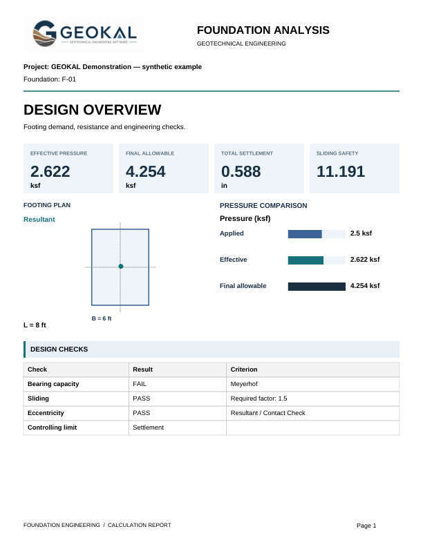
Engineering foundation-analysis output prepared as a report appendix.
Open example PDF
Square-footing stress bulb and depth-based stress-ratio visualization.
View full image
Slip surfaces and factors of safety for a layered soil profile.
View full imageConcept visualizations representing capabilities planned for future GEOKAL development. Features and final implementations are subject to change.

Compare existing and proposed surfaces alongside planned structures, grading geometry, and elevation data.

Visualize grading differences across a site and support preliminary cut-and-fill quantity evaluation while preserving the engineering scale.
Start a company trial or contact GEOKAL to discuss your team’s engineering and reporting workflows.